Thanks Nicholas,
I thing my question was not clear. What I mean is that I have configured the RAK7200 to send data to TTN and there I’m using the decoder script that the RAKwireless web page setting documentation suggest. Decoded data only show latitude, longitude and altitude but not hdop parameter. I’m trying to track the RAK7200 on the TNN mapper and use data to show gateway coverage.
Can i understand your meaning that there no other data other than GPS from TTN? l think it is the parsing script. l found you used GPS take six decimal places.
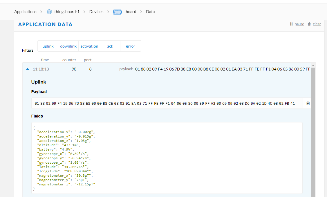
I have already put the script that TNN mapper suggests, and now the one that you suggest me too. They both make the GPS data available, but I understand that the one you send builds the object that TNN mapper expects, however I understand that the “hdpo” parameter is still missing … Check this out on the TNN mapper page:
Make sure you have a Payload decoder function enabled on the TTN Console that decodes the raw payload into a json object. The JSON object should contain the keys " latitude ", " longitude " and " altitude " and one of " hdop ", “accuracy” or “sats”. When using the Cayenne LPP data format, the GPS coordinates will be decoded into a different JSON format, but this format is also supported. Cayenne LPP does not contain a GPS accuracy, and therefore this data will be considered as inferior and will carry less weight in calculation of coverage, and will be deleted first during data cleanup.
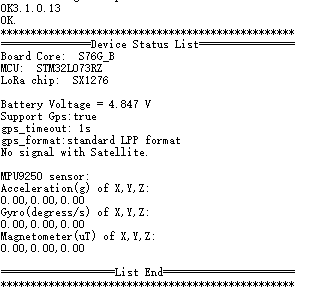
This is a copy of the decoded data using the script you suggested me:
{
“DecodeDataHex”: “018800de83c3fa9a4e58000245ae0802017c”,
“DecodeDataObj”: {
“battery”: “3.80V”,
“gps”: {
“altitude”: “1489.1m”,
“latitude”: “14.582723°”,
“longitude”: “-90.550696°”
}
}
}
If someone can provide the source to the 7200, it should be possible to alter it to transmit data in a suitable format including hdop & fixes.
That said, rather than using Cayenne forma, you could use the 7200 coupled to the mobile app (Android or iOS). TTNMapper will pickup RSSI & SNR from the gateway meta data and the GPS data it needs via the app.
Nick, thank you very much for your comment.
It happens that I bought the RAK7200 for that purpose, but I admit that I did not take the time to investigate a little more about it before buying.
I will look for an application or a different way to take advantage of the RAK7200, which by the way I can see that the GPS that it has integrated is not as sensitive as I expected.
For my purpose of recording gataway coverage, I will continue to use my prototype based on a SparkFun SAMD21 board and the Android app. Thank you very much to all.
@Nicholas, the 7200 does not give the hdop (horizontal dilution of precision) or number of satellites the GPS has a fix on that TTN Mapper needs - this is not a deficiency in the 7200 but unless you choose to change the firmware, there’s nothing more to do.
Then the iOS app has bugs, it doesn’t show me anything, I have to toggle its radio buttons several times to make them “work” somehow, but my tracing is still not there and all counters are 0. But its connected: Production